"Space Has a Scottish Accent": Meet Space Aye CEO Chris Newlands, The World’s 4th Most Influential Space Entrepreneur Whose Space Strategy Is Changing How We See Our World
Meet Chris Newlands, the Scottish entrepreneur who ranks 4th among global space leaders after Musk, Bezos, and Branson. His company Space Aye is changing how we see Earth from space by combining real-time satellite images with IoT data.


Deep in Glasgow's tech corridor, a former Royal Navy trainee officer turned financial expert steps from his shower with a million-dollar idea: what if you could take a selfie from space? This simple concept—capturing an image of a person in a satellite image from orbiting satellites in real-time—would propel Chris Newlands to fourth place among the world's top space entrepreneurs, behind only Musk, Bezos, and Branson.
Now as CEO of Space Aye, Newlands has transformed his "space selfie" concept into groundbreaking technology that merges satellite imagery with IoT data, secured by patents across the US, China, and key Asian markets. His vision for 2030: thousands of orbital cameras providing an always-on view of Earth that could revolutionize everything from wildfire management to finding missing persons—all starting with that simple idea of proving you were really at Coachella.
As someone who served in the Royal Navy and then spent decades in financial services, what sparked your initial interest in space technology and led you to found Space Aye? Was there a specific moment or realization that drove this transition?
I think space is just exciting. People get excited by it, and everyone has their own perception of space. Some think of "live long and prosper" from Star Trek, while others picture the moon landings. It captures the imagination in so many ways. I've always been drawn to it. I'm quite scientific in my mindset, and my time in the armed forces naturally ties into the defense and dual-use aspects of space. In a way, stepping into this industry felt like slipping into a comfortable pair of slippers—the community relates to me, and I relate to them.
The idea for Space Aye literally came to me in the shower, as most of the best ideas do. I had met a couple of space scientists who told me, "If you can find a business model that effectively derives data from space, there are grants available from the European Space Agency." I asked them if they had any ideas and they said “no, apparently you’re the ideas man.” At the time, I was working on Talk Holiday, a social network that connected travelers before their trips—kind of like an interactive TripAdvisor. If I hadn't been working on that, I would have jumped into space sooner. That experience, especially the user-generated content aspect, helped shape my thinking about space data.
Space Aye Video Explainer
So, there I was, in the shower, thinking about how space data could enhance a business model. Satellite navigation was the obvious angle, but what really hit me was the frustration of spending a fortune on paid advertising on social channels, like Facebook, Instagram, Google—you name it - where you have to constantly spend to stay visible. I started thinking: How could space help brands connect with younger people more ‘organically’? Especially those at music festivals, where experience matters more than ten Rolexes or owning a Ferrari.
Young people take selfies—it’s a cultural staple. They also go to music festivals. What if we could capture experiences from space? Not just checking in, but actually proving attendance using satellite imagery? Take Woodstock, for example—five times more people claim to have been there than was actually possible. So, the idea of "space selfies" was born. No one had done it before. I got two space companies to sign NDAs and non-compete agreements, and we decided to partner with Airbus Defence & Space. They were interested in the consumer-facing side of real-time satellite imagery, seeing it as a potential B2C play with huge engagement potential. That led to applying for patents—I figured if these giants hadn’t thought of it, I must be onto something. We patented the ability to task a satellite to identify people or assets in real-time satellite imagery. The U.S. patent was granted in 2021, followed by China, South Korea and Japan;Europe and Canada are pending.

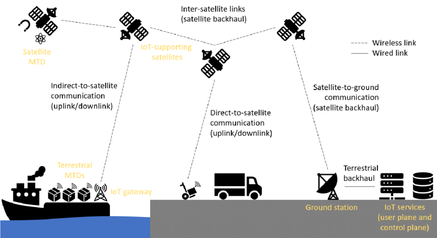
Essentially, we control the relationship between real-time satellite imagery and IoT data, giving us the ability to see the whole world in context. That was a game-changer. At first, I wasn’t even thinking about security applications—I was focused on commercial opportunities. But the security side naturally became relevant too.
Looking back, my transition from the military to financial services taught me how to raise money without relying on VCs and angel syndicates. Moving into entrepreneurship helped me understand brand-building. And now, in space, I realize the timing was perfect. From 2017 to 2019, the commercialization of space truly took off, and I happened to be in the right place at the right time.
Space Aye's vision of merging IoT data with real-time satellite imagery is ambitious. Could you elaborate on specific use cases where this combination could have the most significant societal impact?
It might seem ambitious, but we’ve already built a demonstration platform that automates satellite tasking—removing the need for human intervention. There are over 20 different image formats in use today, and that lack of standardization is a real challenge. As a capitalist, I appreciate unique selling points, but when it comes to interoperability, it’s a nightmare. Our technology solves that by converting those formats into a single, universal standard—completely automatically. Combine that real-time imagery in all spectra with IoT data, that gives us an unique advantage, which only patents allow.
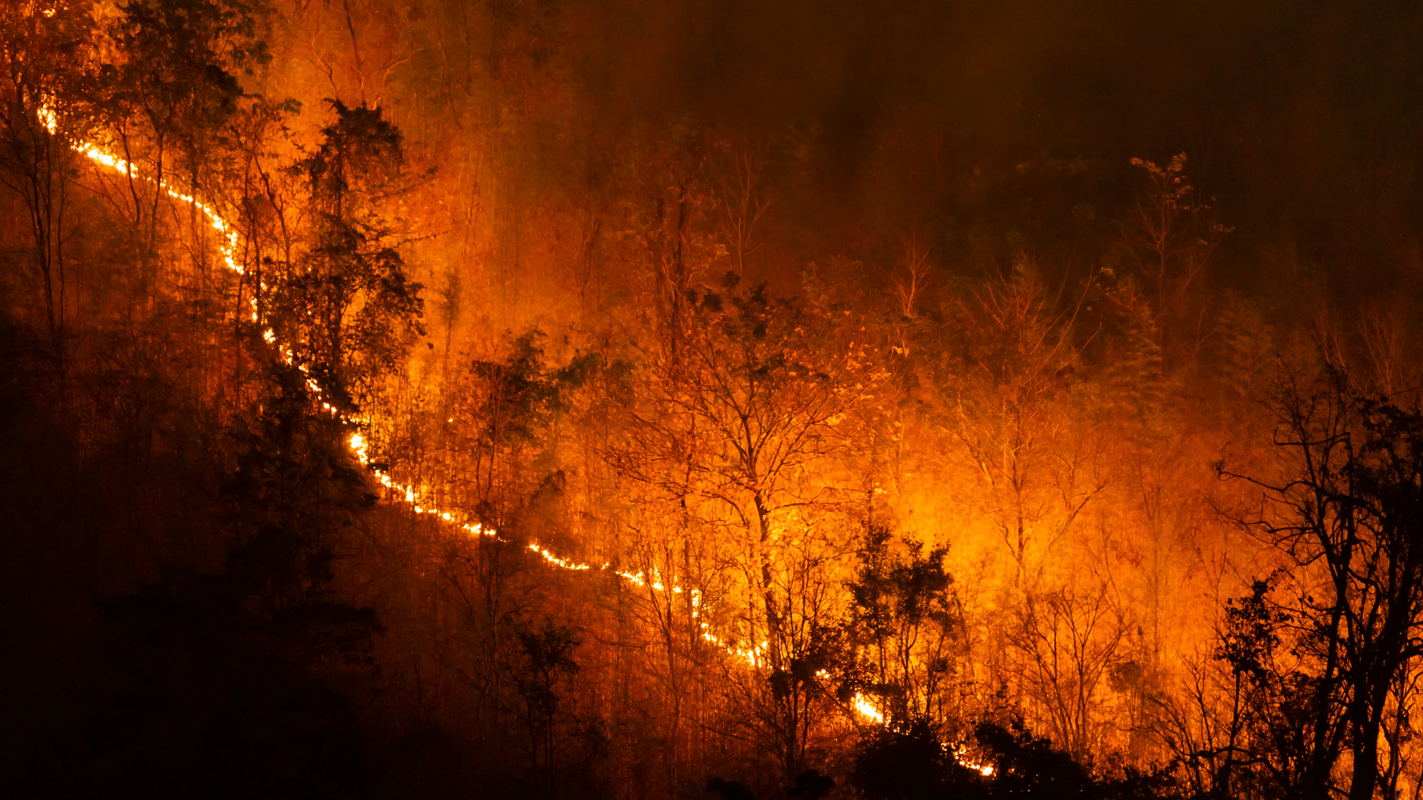
We recently committed to providing certain capabilities to the United Nations as part of a non-profit initiative focused on planetary transformation. We’re not just here to make money for shareholders—we want to do good, too. A great example is wildfire response. It’s one thing to see a wildfire from space, but another to track first responders in real time in direct relation to the location and direction of the live fire, ensuring their safety while more effectively coordinating relief efforts. The same goes for protecting civilians, livestock, and wildlife. Better situational awareness could allow us to contain fires days earlier—think of the devastation in Maui or the North Carolina floods. Many disasters are made worse by poor coordination and communication between people and assets. Space technology can change that.

For more details on how Space Aye is driving progress across the UN Sustainable Development Goals, explore this Interactive Impact Infographic to see real-time applications in action.
Another powerful use case is deforestation. Right now, the industry tracks deforestation in the Amazon rainforest over six-month intervals. By the time the damage is reported, it’s already happened. But with real-time satellite data, we could actually identify and catch illegal loggers in the act and help authorities intervene. There have even been reports of indigenous communities being massacred over land disputes, simply because they have no way to prove ownership. Real-time imagery, merged with IoT data could literally help save lives.
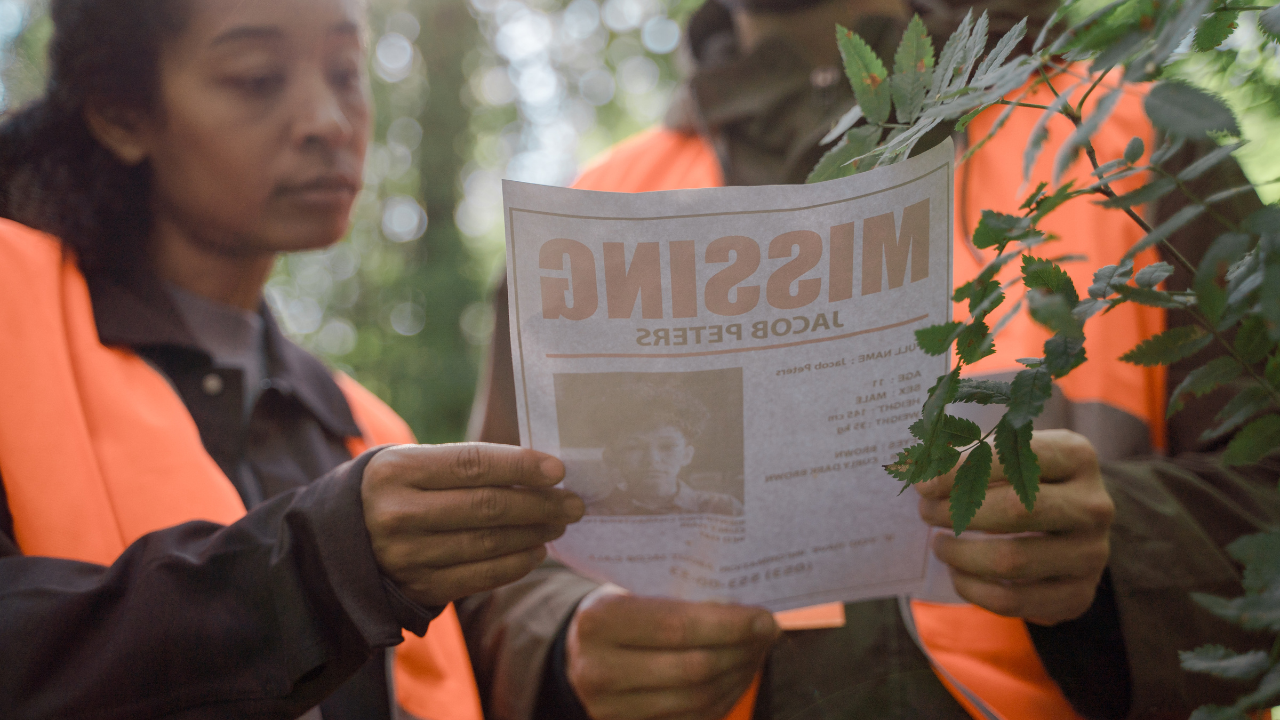
From a security standpoint, the possibilities are endless—monitoring missing persons, vulnerable children, human trafficking, border security, and even pandemic management. In the UK, a significant amount of the police budget is spent on missing persons. What if we could locate them faster using biometric and geospatial data? That alone could save millions.
And then there’s autonomous transportation. Self-driving cars and drones rely on LiDAR and onboard cameras, but that’s not enough for true mass-market adoption. Real-time satellite navigation—seeing the road five miles ahead, east and west in almost real-time—will be crucial for the future of transport. Just imagine the impact of shaving 1 or 2 minutes off an ambulance’s response time. That’s the difference between life and death.
Ultimately, technology can solve problems even when organizations rarely work together. We can act as a neutral broker, bridging those gaps. The impact will be massive—both commercially and societally.
Read more about how Space Aye is converging real-time satellite imagery and IoT data to enhance decision-making across industries: Satellite-Tech Europe.
As Co-Chair of the Open Geospatial Consortium in the UK & I, what do you see as the key challenges in standardizing and coordinating the use of real-time satellite data across different sectors and stakeholders?
This is where things get politically tricky, so let me try to be both diplomatic and direct. In my previous life as a chartered financial advisor and non-executive director in financial services, I saw firsthand how difficult it is to get consensus. If you put 100 investment analysts in a room, you'd get 100 different market related opinions. Now, apply that to geopolitics and technical standards, and the challenge only multiplies. Some players benefit from delaying progress, while others push for rapid development, making consensus-building, a long, drawn-out process.
Personally, I'm someone who prefers action over endless discussion. Instead of waiting for consensus, I believe the best approach is to build technology around intellectual property and take decisive steps forward. Our patents, in a way, can help set the rules, where none exist in the space domain. There are no universal laws governing space derived data, but by securing patents across key global markets—including Asia, Europe, and the U.S.—we’ve essentially created a framework for structured innovation in space, which could and should be adopted globally.
Think of today’s digital world as a vast live web page, with 8 billion people interacting within real-time satellite imagery. That level of connectivity demands structure and compliance with privacy laws; otherwise, it descends into chaos. We need clear rules for how we engage with real-time satellite data. While discussions are important, taking tangible action is what truly moves the industry forward, whilst complying with privacy benchmarks.
One major challenge is the lack of interoperability. There’s little standardization in satellite tasking, and collaboration between stakeholders is limited. The solution? Acting as an honest broker. By sitting in the middle and representing the customer, we make access to satellite data easier, drive more sales for satellite providers, and lower costs, which will ultimately improve sales volumes and returns on investment for investors. That’s the ideal scenario.
Analysts predicts thousands of cameras in space offering a near "always-on vision" of Earth by 2030. How do you balance the commercial opportunities this presents with privacy concerns and ethical considerations?
As both a consumer and a businessperson, I see this issue from two perspectives. First, let’s talk about 'perceived privacy.' Many people believe they have privacy, but in reality, everything is being tracked. When you watch a football match, for example, the advertisements on the digital banners behind the players are tailored to your location and profile—completely different from what someone else sees watching the same game. Your phone listens to you, Google tracks your movements months in arrears, and targeted advertising ensures you're constantly monitored in ways most don’t even realize.
That said, people shouldn’t lose sleep over it. If you’ve got nothing to hide, there’s nothing to fear. Plus, regulations like GDPR exist for a reason. But privacy is a fluid concept—what it means in one part of the world is completely different in another. In certain countries, there’s barely a word for 'privacy' beyond its association with the honeymoon night. The global perspective on privacy varies widely.
At the core, I believe privacy must be treated as a fundamental requirement, but it’s also a trade-off. We all exchange some privacy for security, safety, and convenience. Imagine waking up and checking your phone to see real-time traffic entering your city, allowing you to decide whether to drive in or work remotely to reduce pollution and congestion. That’s a game-changer.
AI expert Yann LeCun recently said at Davos that large language models will soon run out of training data. The ability to power AI with real-time, verifiable satellite imagery & IoT data will also revolutionize decision-making. Imagine AI not only recognizing a red Ford Fiesta but identifying the driver and detecting their stress levels or the car’s tyre pressure or oil levels—this could save lives or improve efficiency.
Some find this level of visibility terrifying, but it already exists on maps, where visual context of your surroundings has enormous benefits. If an incident occurs, authorities would have irrefutable evidence to convict criminals. If a self-driving Uber is delayed, you’d be able to see why, rather than just watching a black dot on a map. We’re not creating a dystopian surveillance state; we’re enhancing GPS by adding live imagery to provide real-time context. It’s simply a more advanced, informed way to navigate the world.
See Space Aye in action—watch our explainer video to discover how real-time satellite imagery is transforming global decision-making: Everything. Everywhere. Now... Space Aye on Vimeo.
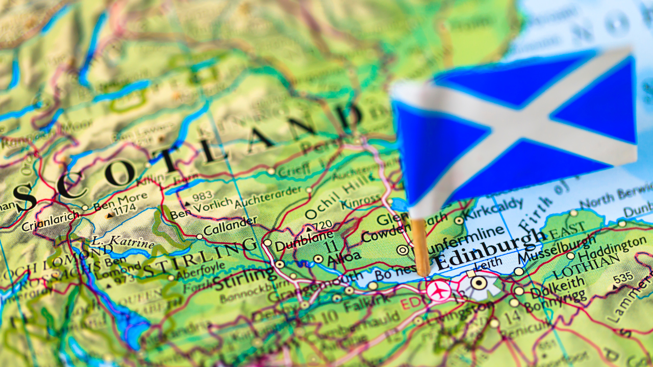
How do you see Scotland positioning itself in the growing commercial space sector, and what unique advantages does Scotland offer to space-related businesses?
Controversial comment—ITAR could be accused of limiting commercial space use cases. The reason I say that is simple: we can't just use satellite imagery for defense and security purposes. There are so many different use cases, and Western governments need to be the ones setting the rules globally, rather than having them imposed upon us. Should an unfriendly nation decide to offer open access to this data set, this could be problematic.
Scotland plays a unique role in this. We’re positioned as an honest broker—not directly bound by ITAR restrictions in the way that some other nations are. That gives us flexibility. To be clear, we are not looking to circumvent ITAR regulations; we’re looking to foster innovation, while ensuring security and create a truly commercial Earth observation sector. This offers more security, not less…
Space Aye’s contributions to global space governance were recently recognized as it became the first Scottish company invited into The Washington Compact. Read more about this milestone in Grit Daily News.
Commercial space offers the ability to observe and analyze every element of the world, from disaster relief and environmental monitoring to oil spill detection. The ability to use satellite data in real-time navigation is a game-changer..
Scotland has a long history of invention. I am an inventor myself—the patents we’re discussing today were invented by me. Historically, Scotland has produced everything from the flushing toilet and television to radar and penicillin. Space is just the next frontier where Scotland can make an impact. In many ways, space has a Scottish accent—our history of innovation speaks for itself.
We share many of the same values as the global space community, but we need to help policymakers understand that limiting innovation through outdated frameworks like the Wassenaar Arrangement and also ITAR it can actually hinder our progress. If we don’t push forward, bad actors will surpass our capabilities. It’s like clinging to a Nokia 5210 while others have smartphones—we need to play to our strengths and use our intellect, where we have challenges.
Scotland has the talent and the potential to create a thriving space ecosystem. Glasgow is already the third-largest satellite manufacturer in the world. Our influence is growing, but we need to push even further. Space technology can make society fairer and more secure—situational awareness is just as critical for defense and security as it is for commercial & societal applications. Scotland has a real opportunity to lead in this sector.
What excites you most about the future of space technology in the next 5-10 years, and what milestones are you anticipating for Space Aye?
I’m obviously biased toward what we’re doing, as we and others genuinely believe it’s revolutionary. What we’re developing isn’t just a product—it’s a capability. Think of AI: it’s not a single tool but an embedded technology that enhances countless applications. That’s how I see our work with real-time satellite imagery and live IoT data integration developing.
Situational awareness is about to take a massive leap forward. AI can classify objects—classify cars, their makes, models, and colors—but it can’t yet tell you the registration number or who’s driving them. Our technology can. That level of intelligence will transform decision-making in areas from security and fraud prevention to wildlife conservation and disaster response.
I’m particularly excited about Earth observation. It’s long played second fiddle to communications, but that’s changing. Starlink has disrupted global connectivity, and while I don’t agree with everything Elon Musk says or does, there’s no denying his positive impact on the industry. His ability to launch at scale has reshaped space access. Imagine applying that principle to Earth observation—what if you could book a satellite tasking slot by the hour, minute or second? That’s the future we’re heading towards.

My vision is that in the next decade, we’ll see the ability to request satellite tasking in near real time, just as easily as booking a rideshare. That shift will completely transform how we deploy and utilize space assets. The ability to task automatically, on demand, will be a massive step forward for both commercial and defense applications.
The real breakthrough will be the shift from simply using AI to analyse satellite images to the data pulsing from billions of Iot devices, merged with real time satellite imagery powering AI models by creating a verified training data set. Our “Large Terrestrial Model” (LTM) is currently in development, improving everything from search and rescue operations to supply chain logistics.
Another game-changer is direct-to-device satellite communication. The days of solely relying on ground-based networks are numbered. Soon, every corner of the planet will be connected in real-time, and that has profound implications—both positive and negative. Total connectivity brings challenges, but it also opens the door to more informed and responsive global decision-making.
In many ways, it’s not about a single technology but about creating an ecosystem where multiple innovations work together seamlessly. AI, real-time satellite imaging, IoT, and direct-to-device communications will converge to reshape how we interact with each other and our world.
The next decade will be defined by speed. The old ways of doing things—slow-moving bureaucracies and legacy infrastructures—aren’t enough anymore. We need to adapt, innovate, and act fast. That’s exactly what we’re building toward at Space Aye.
About Chris Newlands
Chris Newlands is one of the UK’s most connected entrepreneurs in the Technology and Space sectors. In December 2021, he was named in 4th position, in the world’s top 10 space entrepreneurs list, beaten only by Branson, Musk and Bezos. He was featured by Computing in their Top 100 IT Leaders “Definitive ranking of the UK’s foremost technology professionals 2024” list.
After serving in the Royal Navy, he carved out a successful career in financial services as a Chartered Financial Planner and NED. Over the last decade, Chris has become a true entrepreneur, creating Space Aye Limited, supporting his patented method that controls the merger between IoT data and real-time satellite imagery.
In 2021 the Scottish Government awarded him the title of Global Scot and became a Professor of Practice in entrepreneurship. He is an Affiliate Member of the Scotland International Space Advisory Committee, the Co-Chair of the Open Geospatial Consortium UK&I Forum and a Member of the World Geospatial Industry Council.
Currently lives near Glasgow, Scotland, also known as “Satellite City” with his wife and children.
To learn more about Space Aye’s groundbreaking technology, contact Chris Newlands at info@spaceaye.com or visit www.spaceaye.com.